
OSM Scout

OSM Scout for Sailfish is map viewer with search and navigation, fully functional without internet connection.
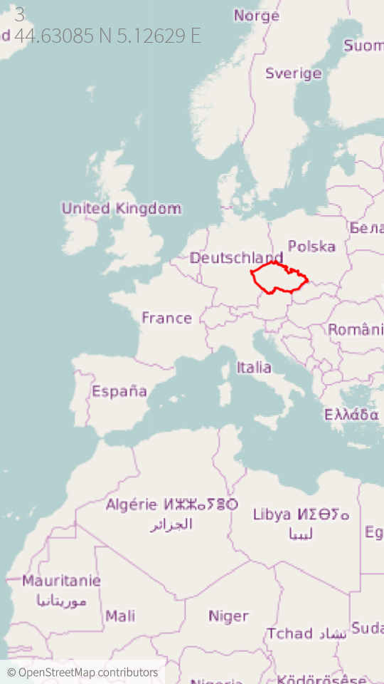
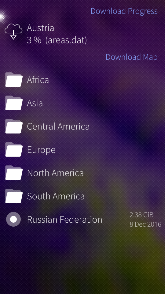
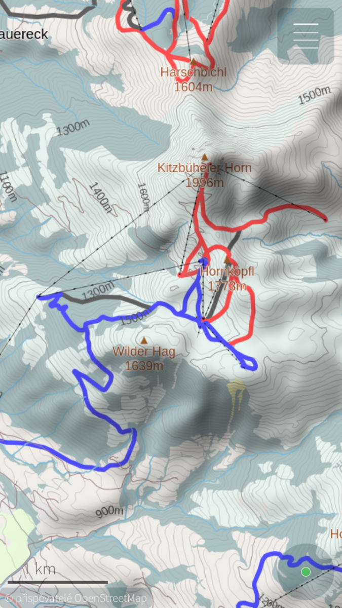
You can choose one from multiple map styles: standard, outdoor, public transport or winter sports. All with the same database that can be downloaded (per state) directly from the application for offline usage. Data on the server covers whole planet and are updated monthly from OpenStreetMap data. You can generate your own extract eventually, all tools are open-source and OpenStreetMap data are free!
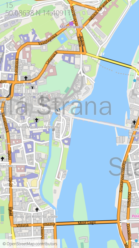
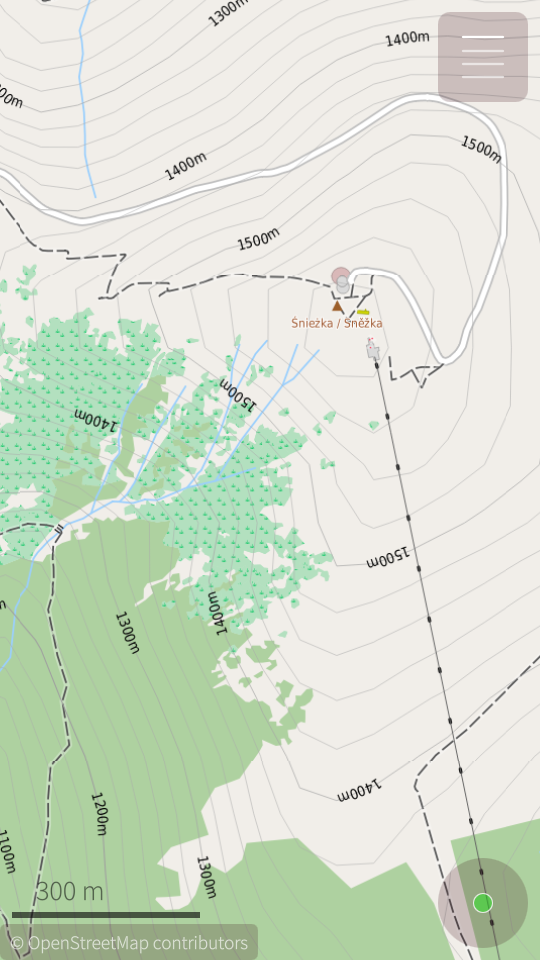
For better outdoor experience, databases (almost all) contains elevation contours and hillshade overlay (online) can be displayed. For areas not covered by offline data are used online maps provided by OpenStreetMap or Stamen Design. But search and navigation works only with offline data.
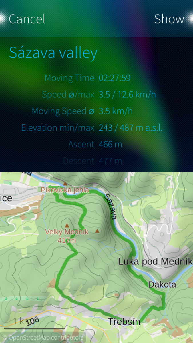
Your favourite places (waypoints) can be stored to collections and exported to GPX files later. It is even possible to import tracks and waypoints from GPX files, display it on map or show simple statistics.
OSM Scout for Sailfish OS is developed as open-source (GitHub) by volunteers in their free time. You can help to improve this application by reporting bugs, creating translations or developing new features. Any help is welcome.
Screenshots:
Category:
Keywords:
Application versions:
| Attachment | Size | Date |
|---|---|---|
| 2.34 MB | 18/12/2025 - 02:30 | |
| 2.28 MB | 18/12/2025 - 02:30 | |
| 2.24 MB | 18/12/2025 - 02:30 | |
| 2.93 MB | 23/02/2026 - 01:47 | |
| 2.86 MB | 23/02/2026 - 01:47 | |
| 2.82 MB | 23/02/2026 - 01:47 | |
| 3.75 MB | 26/05/2026 - 23:52 | |
| 3.85 MB | 26/05/2026 - 23:52 | |
| 3.79 MB | 26/05/2026 - 23:52 |
Changelog:
* 2026-05-24 v2.43
- fix regression: render overlay objects even when offline map is disabled
- search in basemap, it allow to search country names or capital cities even in case that specific map is not downloaded
- fix daylight switch, when some area patterns do not update its colors
- fix: loading missing route data on stylesheet change
Full changelog on Github
Comments
zipotron
Tue, 2024/12/03 - 12:04
Permalink
Hello Karry, as always, thanks for this amazing work. Just wanted to suggest something for make even better the experience using your app. Is in the search feature, when you search the name of a place, in the result list appears all the coincidences, but is just a list of the same name repeated, then if you dont know well the place you are serching, is impossible to know which one is the right... Could you add the name of the region/town to those results? This would be really helpfull for users. Thanks a lot.
Karry
Thu, 2024/12/12 - 01:36
Permalink
I know, it is big disadvantage of results from prefix search index (using Marisa library). It have no link to region. It is possible to do reverse region lookup by location, but it is pretty slow for all search results :-/
Solution would be to extend the index or do location lookup asynchronously... Doable, but it is not trivial work. I will add it to my todo list
sistux
Tue, 2024/07/23 - 13:05
Permalink
Hi! Thanks for application!
May be I misunderstood something and my question is, whether it can work as an oflline-map-server? for example, pure-maps. osm-server is not updated.
Can you give me some info?
Thanks and regards!
Sergej.
Karry
Thu, 2024/12/12 - 01:30
Permalink
Nope. This app doesn't provide web server that would be usable as tile server. For "OSM Scout server" contact its developer, Rinigus.
dbanomer
Sun, 2024/05/19 - 20:16
Permalink
Hello, thank you for the excellen navigation app. It works for me as a hiker. Question though, how do I upgrade for the fresh version without loosing all my previous collections? Is there some database which can be saved and then restored? I am thinking pulling this database (files) over scp to the outside of the phone and then placing it back after the new version is installed. ?
Karry
Thu, 2024/12/12 - 01:29
Permalink
yes, it is possible. collections are stored in sqlite database, here: /home/defaultuser/.local/share/cz.karry.osmscout/OSMScout/storage.db
you can also use "My backup" application and include OSM Scout collections to ordinary system backup
elkiaer
Sun, 2023/09/17 - 10:46
Permalink
Sorry, do not know where to look for it.
elkiaer
Thu, 2023/09/07 - 13:09
Permalink
Have I missed something, is it not possible to search for a specific house/number on a road ?
Karry
Thu, 2023/09/07 - 21:35
Permalink
Hi. It should be possible in general. When it is not working, take a look to openstreetmap data, if the address point is correct - it has addr:street or addr:place tag. When yes, and search is not working, feel free to open issue on github with full description - what offline map do you have and what phrase you want to trying to search.
Thank you.
slava
Mon, 2023/08/28 - 23:32
Permalink
harbour-osmscout-2.31 on Sailfish OS 4.1.0.24 white screen:
[W] unknown:32 - file:///usr/share/harbour-osmscout/qml/main.qml:32:9: Type MapPage unavailable MapPage{ ^ [W] unknown:22 - file:///usr/share/harbour-osmscout/qml/pages/MapPage.qml:22:1: module "Sailfish.Share" is not installed import Sailfish.Share 1.0 ^Karry
Wed, 2023/08/30 - 00:27
Permalink
Hi. Share QML api was changed few releases back (I think that it was in 4.3). So, this build of OSM Scout require SFOS 4.3 or newer (not sure with exact minimum version). For usage on older releases, you may try to use https://openrepos.net/content/karry/osm-scout-jolla-1 , sharing functionality is removed there.
slava
Tue, 2023/09/05 - 01:16
Permalink
I know, it's only 3 qml files, I just edited those on the device. FYI there's a way to detect SFOS version and do the right thing at run time which is what Foil Pics is doing. But I agree that it's a pain in the ass for the developer (and for users too if the developer decides to maintain different builds for different versions of SFOS)
zipotron
Mon, 2023/07/24 - 15:25
Permalink
Hi Karry, another bug I wanted to report, from few months I have the issue of, when I am navigatting with car (walking ins not happening, or just didnt happend to me) and I am playing music in the same time, the music player crash after few minutes. This start happens after a system update like half year ago (not last one), at the beggining I thought that was a bug in Talefish (the player) triggered by the system update. But because stills happend after last week system update, I tryied to install another music player, I tryied Unplayer, and stills happend the same. Then, two media players chashing when Osmscout is running... Maybe the bug is in Osmscout? Is not a big issue, but the behaviour demativate a lot in real life. Thanks!
Karry
Wed, 2023/07/26 - 20:19
Permalink
Hi, I would suspect that lowmemorykiller kills all applications on the background. OSM Scout is memory demanding, especially during navigation. Did you look to system log what happened?
zipotron
Thu, 2023/07/27 - 14:29
Permalink
Hi! Unfortunately your suspect is completely right, and my Xperia 10II is victim of the programmed obsolescence... I have a suggestion, would be amazing to have in "configuration" area the option of limit the maximum RAM available for OSMScout, then avoid this issue. I think a lot of ussers with old devices would aprreciate. Anyway, this app is an amazing job, thanks for it!
eisbaerle
Wed, 2023/07/19 - 22:53
Permalink
Thanks for the excellent work!
zipotron
Mon, 2023/07/10 - 22:33
Permalink
Hi! I was observing from some months ago an error in the contour lines of the map, at least here in Spain. All of them are labeled with the twice of the real altitude.
Karry
Mon, 2023/07/10 - 23:17
Permalink
Hi. Can you share more details please? Screenshot, coordinates, date of the map database, version of the app... I am not aware of any change that may influence countour lines...
defactofactotum
Wed, 2023/07/12 - 11:14
Permalink
Hi Karry, I have this too. Higher altitudes are notexactly double, a bit more; lower down, my house should be 250 but it's 400+. I tried toggling to imperial and back, no luck
I could attach a screenshot but it seems I can only link to one and I don't know where to park it.
zipotron
Tue, 2023/07/11 - 16:06
Permalink
I dont find the way to upload a capture in openrepos.org, I tried but noway. But you just search for "Granada" in wikipedia, and then check the contour lines arround Granada in Osmscout and you will see the bug. I am using the last Osmscout and the maps are updated.
Karry
Tue, 2023/07/18 - 00:45
Permalink
Hi guys. I am able to reproduce this issue with "Apls" map database. It is strange that elevations in Austria map are fine. I will look on this issue asap.
Karry
Tue, 2023/07/18 - 01:22
Permalink
Found the bug. It was stupid (all bugs are). It will be fixed in the next relase: https://github.com/Karry/libosmscout/commit/fa239ccc693f60ab8910b718ce8d...
zipotron
Mon, 2023/07/24 - 15:18
Permalink
Awesome, Thanks!
defactofactotum
Wed, 2023/07/19 - 12:24
Permalink
Great work, thanks
kaulian
Tue, 2023/07/18 - 11:54
Permalink
Thanks for this fix
defactofactotum
Thu, 2023/04/20 - 14:49
Permalink
Hi Karry, would it be possible - or is it already possible to navigate to an existing downloaded map on device or sdcard? I've had to reflash several times recently and the download of 2GB is very slow. Thanks for this great app.
Karry
Fri, 2023/04/21 - 09:16
Permalink
Hi, I am not sure if I understand your question. If the maps are stored on sd card in "Maps" directory, OSM scout should find it. But there is no option in the app to choose map location.
defactofactotum
Mon, 2023/05/01 - 11:32
Permalink
Hi Karry, this certainly works if I transfer the map to the device but not to an sdcard...but I may be wrong as I foolishly made 2 partitions on my sdcard.
Karry
Tue, 2023/05/02 - 22:42
Permalink
Two partitions may be the trouble. Take a look to the code that detects mountpoints: https://github.com/Karry/osmscout-sailfish/blob/master/src/OSMScout.cpp#...
It have to be detected by Qt `QStorageInfo::mountedVolumes()`, and mount point hat to start with `/run/media/`. When it is not detected, try to run OSM Scout from terminal and look to the debug log.
zipotron
Thu, 2023/01/19 - 17:47
Permalink
Hello Karry, your app is amazing, but something change in the prelast, or three versions ago, and now, the altitude is showing right until 1500 metter high, after that, the altitude is shown in KM (1,6 km -> 1,7 km), and is loosing precision. I see it as a big regression if you use the app for montainiering. please, consider to go back to the old state, specially because the app already is working as the old until 1499 m, I mean, is not saving space in the screen anyway. Thanks a lot!
Pages