WhoGo Maps
WhoGo Maps is in minimal maintenance mode. If it no longer works, or if you're interested in new features, please try Pure Maps, a continuation of the same codebase under new maintainership.
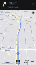
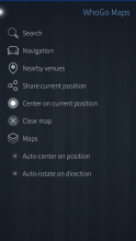
WhoGo Maps is a full-featured app for maps and navigation with a flexible selection of mostly OpenStreetMap-based maps and related service providers. WhoGo Maps requires the Mapbox GL Native QML component for map display, supporting both vector and raster maps with OpenGL accelerated rendering.
Offline maps, search and routing is possible with OSM Scout Server. WhoGo Maps will list OSM Scout Server among the providers if you have it installed. For it work, you'll also need to have the server running and map data on your device. See the OSM Scout Server documentation for details.
Voice navigation requires that you manually install a text-to-speech (TTS) engine – Mimic, Flite, PicoTTS and Espeak are supported. Their quality is about in that order, with Mimic being best and Espeak being worst, but their language and gender coverage varies.
Source code and issue tracker are available at GitHub. Translations at Transifex. Discussion at TMO.
Category:
Keywords:
| Attachment | Size | Date |
|---|---|---|
| 429.48 KB | 25/03/2018 - 20:33 | |
| 455.08 KB | 12/06/2018 - 22:44 | |
| 461.98 KB | 18/06/2018 - 23:41 | |
| 469.06 KB | 04/08/2018 - 15:36 |


Comments
Pohli
Thu, 2018/08/30 - 04:45
Permalink
It would be nice if there was a note on the description page of WhoGo Maps with a link to Pure Maps like there already is on the description page of Poor Maps to WhoGo Maps.
otsaloma
Thu, 2018/08/30 - 21:36
Permalink
Done.
mixmax
Fri, 2018/08/17 - 11:20
Permalink
Thks a lot for those aswers. OSM Scout server is installed, and all needed data are saved. I will search again in configuration (in OSM Scout server or Whogo Maps ?)
Regards
rinigus
Sat, 2018/08/18 - 12:18
Permalink
I presume that this search is regarding offline use. You could check out osm scout server user's manual (available online, see about page of the server) and follow description of Poor Maps configuration in the manual. Poor Maps is predecessor of WhoGo Maps and the options are almost the same. Let me know if something was not clear in the manual here or opening an issue at osm scout server github repo.
mixmax
Sat, 2018/08/11 - 12:45
Permalink
Hi,
first of all, congratulations for your work !
And, 2 questions :
- it seems impossible, or I didn't found the feature, to have choice among several routes ?
- I have no result from route searching without network. Is it possible, and how ?
And to finish, 2 wishes of features :
- Auto zoom according to speed,
- possibility to save and view on the map my favorites points (house, office, ...)
Thanks again for your work, and for what you can do for my questions.
rinigus
Wed, 2018/08/15 - 10:03
Permalink
Multiple routes: I don't know about other routers, but Valhalla doesn't support it yet. There is also a question regarding automatic rerouting - that would be dangerous to choose route while driving.
Offline: OSM Scout Server is written to allow you to use this application offline. This includes finding the routes. If you have the server installed, then either the data is missing or there is some misconfiguration.
AutoZoom: please open an issue at github regarding it. Do you know any good implementation of it? I would expect that finding the right zoom levels is the main work.
Saving POIs: this is planned, corresponding issue is already opened.
Markkyboy
Wed, 2018/08/08 - 10:34
Permalink
Gracias!, excellent work!, my new means of navigation!, now I can remove Android Sygic :) *****
lsjmhar
Tue, 2018/08/07 - 20:25
Permalink
Got the while thing working. Thanks rinigus, this is a fantastic app with great functionality. Hopefully we can increase the voice navigation as noted above but the navigation is excellent!!!
lsjmhar
Tue, 2018/08/07 - 14:19
Permalink
Hi. I have mimic installed but I am not getting voice navigation on this app. What could be causing this? Thanks
didilalalagon9
Wed, 2018/07/25 - 23:22
Permalink
Hi, Thank you for te good work. few comments that would improve greatly:
-Would it be possible to augment the the time out for the ''auto center'' option. Many time while driving in navigation mode ,pending the zoom level, swiping the maps to have a heads up of the incomming route is nice but the ''auto center'' kick's in before we have even time to finish the swipe at all. Let say , a good 5 sec delay before it recenter the map to the actual position give time enough to swipe, have a good look while safely driving.
- Would be nice to add more tilt ratios for the navigation map view, i would wish to see furter more ahead of my route.
- Incresing the navigation icon/cursor size and color contrast would be apreciated specially while using night mode maps because it become almost invisible from a driving position view point, wnen the phone is on a car holder.
- In the same range, specially in landscape mode the top navigation bar could either be reduce in height and still show same infos (can all be move more closer to the top) or reducing it's opacity to allow a maximum of the map viewing would be great. Also increasing the font size and boldness would help readeability a lot at night and or while wearing polarised sunglasses during driving.
- Voice navigation:
- Is there any way to have it's volume level more louder ? It is at the same level as the general volume stting but let say that a media playback is running in the background at relatively low level, that render the voice navigation bearely intelligible. They would benefit to play a lot louder or have separete volume controls if that is even possible.
-The voice navigation instructions do put in pause the media playback(Jolla mediaplayer) but the playback does not resume aftrewards, adding a command to resume it automatically would be real nice if possible. If it woud risk to initiate a unwanted playback if none was even started during the current navigation it cloud be tie to an aditional option to tick like the ''auto center'' & ''Auto rotate'' that reset to default ''off'' each time WhoGo is open.
Sorry for this extensive ''shoping list'' but I am a long time user of the former Nokia Maps/drive navigation trough out all their iterations on Symbian and Meego to the latest Here wego. Not that i am cool with all the end result (in deed many nice features have disapeared over time). I just wish that WhoGo Maps improve as much as possible.
rinigus
Sun, 2018/08/05 - 19:45
Permalink
Let me help out and give some replies to your requests/questions:
- ''auto center'' can be disabled by pressing on current location or, in the meny, by pressing "Auto center on position". Later, you can restore it using the both ways. Although, please do not browse while driving and do it while still or let non-driver take the map browsing over.
- max tilt is used already and is hard coded into Mapbox GL. cannot help here, there is issues opened regarding it on mapboxgl projects, you find them and monitor the progress.
- I have worked on improving contrast for the night mode. Same goes to rework of navigation mode, including landscape mode and font sizes. The new code will be submitted for review in time.
- voice volume and interaction - haven't worked on it. I would suggest that you could look into it and find the way to fix it. you could look into how mimic produces the audio files and see if there are options to increase the volume. as for media playback - check out how to communicate with media players and try to find the way its possible to re-enable it.
Pohli
Wed, 2018/07/25 - 16:52
Permalink
I found in German directions that the grammar and spelling is wrong. How can I correct this? Is it a matter of WhoGo Maps or OSM Scout Server?
Pohli
Sun, 2018/07/15 - 08:01
Permalink
Hello, I just tried this app on Jolla1 and it seems to be very nice! I didn't use a native routing app so far.
I got two questions about WhoGo Maps:
(1) If I start navigation, the app will automatically switch to perspective view. Is it possible to turn off this behavior and is it also possible to toggle between normal map view and perspective view manually?
(2) If I start navigation or reroute, the Auto-rotate feature will be automatically activated. Is it possible to turn off this behavior and is it also possible to turn off Auto-rotate permanently?
otsaloma
Sun, 2018/07/15 - 13:34
Permalink
Pohli
Mon, 2018/07/16 - 17:48
Permalink
Thanks for quick reply!
otsaloma
Mon, 2018/07/16 - 18:12
Permalink
mixmax
Thu, 2018/06/28 - 22:37
Permalink
Hi !
I use this app since a few month, and I'm really satisfied. However, I would like to know if it could be possible to create a route without network connection, because for the moment, I can navigate when my device is offline, but not create a route.
Thanks a lot for the job and for your answer.
Pelzlurch
Tue, 2018/06/19 - 22:48
Permalink
You can do that with a long touch. This generates a blue circle. Clicking this, you can navigate to this point.
addy
Wed, 2018/06/20 - 20:05
Permalink
Oh! That is great. I missed that completely. It may be because I haven't spent much time with the software. Another reason being that it seems like a new UI interaction style which people like me are unaware of.
But if we get the option to select both the start and end points on the map, that would solve all the use cases related to navigation.
addy
Tue, 2018/06/19 - 08:21
Permalink
I installed WhoGo Maps and OSM Scout server for offline navigation. Good Apps. Thank you both!
But I was surprised to see that WhoGo doesn't allow to select a navigation point on the map. Due to lack of this feature, navigation is almost UNUSABLE for me because Scout server sometimes returns multiple results and sometimes none for my search query (I know, not the server's fault :)).
So, if you add an option "Navigate here" in long tap menu or allow to select start and end points on the map from the Navigation menu, it would take the whole navigation feature to new level.
That aside, good work guys!
itoss
Fri, 2018/06/15 - 14:45
Permalink
I installed whogo maps and the OSM Scout server for offline maps. The installation of whogomaps 1.0.1 requires the installation of mapboxgl-qml-1.3.0-10.35.1.jolla_.armv7hl.rpm , so i installed that package, too. Using the Scout server Standard configuration Whogo works great ;)
Only the speechoutput doesn`t work
sdiconov
Wed, 2018/06/13 - 01:29
Permalink
Russian translation updated following the 1.0.1 release. Some strings were too long.
Yeum
Sat, 2018/06/09 - 23:39
Permalink
I'm also having trouble starting WhoGo after the recent patch; If I use the icon from the app launcher, it will not start (shows loading icon on app screen, then just disappears after a timeout)
However, if I use the command line "sailfish-qml harbour-whogo-maps", the app launches & seems to work fine. Removing & re-installing the app did unfortunately not fix the issue either.
wolneykien
Fri, 2018/06/15 - 14:57
Permalink
Same thing! Sailfish OS 2.1.4.14.
otsaloma
Sat, 2018/06/09 - 23:45
Permalink
What recent patch? Which version of Sailfish OS are you using?
wolneykien
Fri, 2018/06/15 - 15:00
Permalink
harbour-whogo-maps 1.0-1
Sailfish OS 2.1.4.14
geminis65
Fri, 2018/06/08 - 23:39
Permalink
I've done it normal and I get this error: ---
| SailfishOS 2.1.4.14 (Lapuanjoki)
'---
[nemo @ Sailfish ~] $ sailfish-qml harbor-whogo-maps
[D] unknown: 0 - Using Wayland-EGL
[D] unknown: 0 - Defaulting to webview scaling factor of 1.0
[D] unknown: 0 - Got library name: "/usr/lib/qt5/qml/io/thp/pyotherside/libpyothersideplugin.so"
[F] unknown: 0 - Can not mix incompatible Qt library (version 0x50602) with this library (version 0x50603)
Aborted
otsaloma
Sat, 2018/06/09 - 00:19
Permalink
You need PyOtherside 1.5.1 or later. Check with "pkcon search name pyotherside" if you have that.
geminis65
Fri, 2018/06/08 - 23:37
Permalink
I have become accustomed to using devel-su
geminis65
Fri, 2018/06/08 - 22:45
Permalink
I have updated sailfish to version 2.1.4.14 and when I open whogo mpas it does not open and I get the following error: [nemo @ Sailfish ~] $ devel-su
Password:
[root @ Sailfish nemo] # sailfish-qml harbor-whogo-maps
error: XDG_RUNTIME_DIR not set in the environment.
[C] unknown: 0 - Failed to create display (No such file or directory)
[root @ Sailfish nemo] #
.Ruego what you have in mind.a greeting
Pages