WhoGo Maps
WhoGo Maps is in minimal maintenance mode. If it no longer works, or if you're interested in new features, please try Pure Maps, a continuation of the same codebase under new maintainership.
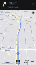
WhoGo Maps is a full-featured app for maps and navigation with a flexible selection of mostly OpenStreetMap-based maps and related service providers. WhoGo Maps requires the Mapbox GL Native QML component for map display, supporting both vector and raster maps with OpenGL accelerated rendering.
Offline maps, search and routing is possible with OSM Scout Server. WhoGo Maps will list OSM Scout Server among the providers if you have it installed. For it work, you'll also need to have the server running and map data on your device. See the OSM Scout Server documentation for details.
Voice navigation requires that you manually install a text-to-speech (TTS) engine – Mimic, Flite, PicoTTS and Espeak are supported. Their quality is about in that order, with Mimic being best and Espeak being worst, but their language and gender coverage varies.
Source code and issue tracker are available at GitHub. Translations at Transifex. Discussion at TMO.
Category:
Keywords:
| Attachment | Size | Date |
|---|---|---|
| 429.48 KB | 25/03/2018 - 20:33 | |
| 455.08 KB | 12/06/2018 - 22:44 | |
| 461.98 KB | 18/06/2018 - 23:41 | |
| 469.06 KB | 04/08/2018 - 15:36 |


Comments
otsaloma
Fri, 2018/06/08 - 22:53
Permalink
Why are you trying to run it as root (devel-su)?
naytsyrhc
Tue, 2018/04/24 - 22:24
Permalink
I have a question: is it possible to start whogo maps by external command with coordinates or address search? If so, we could write a patch for calendar and contacts app to link location with whogo app and open it with corresponding location.
otsaloma
Tue, 2018/04/24 - 23:20
Permalink
Not yet, since I long thought it was not possible, but now is planned. For coordinate arguments it might not be necessary to patch apps though, I'll just make WhoGo Maps a geo-URI handler (mark handling x-maemo-urischeme/geo in the desktop file) and if no other geo-URI handling apps exist, it'll likely work automatically, otherwise you'd just need to set the default mimetype handler. Don't yet know about other arguments like search queries.
https://github.com/otsaloma/whogo-maps/issues/26
naytsyrhc
Thu, 2018/04/26 - 22:59
Permalink
Wow. That's awesome news. Thanks.
pkuronen
Sun, 2018/04/22 - 14:52
Permalink
Works well and looks good. Thanks for your work.
danfin
Sat, 2018/04/21 - 10:17
Permalink
for some reason, whogo maps will not go intor routing. I can give a start and end and a route will be calculated, but it will never display a 'current position', if routing from 'current' psoition search will take forever. Location is on, Device-onl-ode is on.
otsaloma
Sat, 2018/04/21 - 17:59
Permalink
At least that "search taking forever" is some kind of a bug in the code, that shouldn't happen even if GPS isn't working. Command line output would help me. You can try starting as "sailfish-qml harbour-whogo-maps" at the command line, or something like "sailfish-qml harbour-whogo-maps > whogo-maps.log 2>&1" to get the output to a file.
danfin
Thu, 2018/04/26 - 09:18
Permalink
sailfish-qml harbour-whogo-maps
outputs
(D) unknown:0 - Using Wayland-EGL
(D) unknown:0 - Defaulting to webview scaling factor of 1.0
(D) unknown0 - Got Library name: 'urs/lib/qt5/qml/io/thp/pyotherside/libpyotherisdepluging.so
(D) onCompledted:334 - Warning: specifying an object instance for initialPage is sub-optimal-prefer to use a component.
the command to output a file I was not able to trigger. Could've been a typo.
otsaloma
Thu, 2018/04/26 - 21:06
Permalink
Thanks. I don't see anything useful there though.
danfin
Tue, 2018/05/08 - 13:11
Permalink
in 'Storeman' i found a local RPM named Poor Maps, I deleted that, and Whogo seems to work since. (..now If it could read GPX tracks too.. )
objectifnul
Mon, 2018/04/02 - 22:52
Permalink
While PoorMaps is fine with OSM Scout Server, WhogoMaps is apparently unable to trigger the local maps server (selected maps: OSM Scout Day).
otsaloma
Mon, 2018/04/02 - 23:01
Permalink
Try https://openrepos.net/comment/24006#comment-24006
objectifnul
Tue, 2018/04/03 - 10:09
Permalink
Indeed, thx. Perhaps this should be more explicit. Also, it requires re-downloading all installed maps.
rinigus
Tue, 2018/04/03 - 13:51
Permalink
Working on it. The next version of OSM Scout Server will have clearer error message in this case. As for maps redownload, yes, you need Mapbox GL specific tiles which is different from more general object database used by Mapnik
ABreen
Sat, 2018/03/31 - 01:40
Permalink
When I try to install Who Go it shows installing but never finishes the installation.
rinigus
Sat, 2018/03/31 - 10:58
Permalink
Hi! Do you have my repository enabled at OpenRepos? MapboxGL component is available through it and you need it for WhoGo Maps to work.
danfin
Wed, 2018/03/28 - 08:55
Permalink
any plans to ever add GPX import? For a cyclist, also for hikers, it's often better to follow self composed routes.
otsaloma
Wed, 2018/03/28 - 22:05
Permalink
It is on the list of things to do, yes, but not really a priority.
otsaloma
Thu, 2018/03/22 - 00:00
Permalink
Translations now at Transifex. I copied them from Poor Maps and assigned the "poor-maps team" there, so if you have translated Poor Maps, you should have access, otherwise click some appropriate button to join.
axolotl
Tue, 2018/03/20 - 14:28
Permalink
Awesome app!
A little
issuethingy: when clearing the map while navigating, it doesn't switch back from perspective to normal view.Is there a way to remove/rename those "Unnamed points" created by long tapping onto the map, and save (tapped or searched) points for later reuse?
otsaloma
Tue, 2018/03/20 - 23:47
Permalink
That clear issue is a bug, or an oversight, I'll fix it for the next release. There's no POI management, it's planned, but no ETA.
naytsyrhc
Tue, 2018/03/20 - 11:07
Permalink
Thanks for this great update/successor to Poor Maps. Great work.
247
Mon, 2018/03/19 - 18:14
Permalink
Installed it on the j1 and it does work rather well, thanks for your works...anyway some things that wanted to point out
1 rerouting works but it's way to slow, maybe performances on this could be improved?
2 the cursor to me really needs to be changed, as it's too small and it's blue, like povs and the route line so it can be confusing at times
3 there's no way to know if app is connected to gps, so we should rely on the system icon, maybe like here wego you can do a cursor that changes colour when connected and when connecting to satellites?it would be a nice improvement...
otsaloma
Mon, 2018/03/19 - 23:27
Permalink
I'm surprised it works on Jolla 1. That's good to hear, but if something is slow it's still likely to be related to that old hardware and not something that's going to be fixed. Another possibility in some cases is slow network and/or service provider.
The position icon is subject to change, maybe. It's currently still a PNG icon, but Mapbox GL allows offers better drawing options than QtLocation did, so there's options now.
247
Tue, 2018/03/20 - 01:23
Permalink
Thanks for your answer...here are some other things i noticed after a brief try
1 app tends to choose the longest route and there's no way to select other routes other than just start driving and let whogo reroute, it would be nice to have a route selector prior to start navigation
2 selecting a street is way too precise, for example if i am looking for galileo bulevard in rome and i search for rome, galileo street, here wego returns me all the results for galileo in rome, whogo returns me errors until i input the very exact name, maybe this could be changed?
otsaloma
Tue, 2018/03/20 - 02:02
Permalink
247
Tue, 2018/03/20 - 11:22
Permalink
1 probably not as the time i tried it was given me the longest route and when i went my usual road which is the shortest, whogo rerouted to that one, meaning that those route was still present
2 well that was just an example i made but thanks for your suggestion anyway :)
By the way, i had another go this morning and here are other two points :)
1 search needs to be refined, for example, if i need to go into a road which is called "viale turati" i can only search for that by searching for "turati" because searching for viale turati gives me no result (even if turati then gives me viale turati as a result) and even searching for viale turati town name gives me no results, and the only option is to search only for turati and then scroll all the possible results, it can be quite inconvenient at times
2 when i search something i have the list with all the possible results, when i use the navigate function i am prompt with the first navigation route found, for the first road result found, and this may be inconvenient as lot of times the first street found is not the correct adress, i think navigation should have the results list too and then start to navigate
rinigus
Tue, 2018/03/20 - 11:43
Permalink
Would you mind to tell which search engine you were using? If its OSM Scout Server, have you enabled Italian language for address parsing?
247
Tue, 2018/03/20 - 12:49
Permalink
I was using osmscout server and yes italian language enabled. I have anyway discovered that adresses need to be input as "street, town" and not "street town". It solved almost 80% of my problems...shame on me for not trying it earlier :) anyway for that particular road still i need to search it without the "viale" word...dunno why but at least i know is working...
rinigus
Tue, 2018/03/20 - 13:26
Permalink
Please file the issue at https://github.com/rinigus/osmscout-server with example that works and doesn't. I will look into it when I get there, that way I'll remember it :) . I am surprised that it doesn't work well with Italian.
Pages