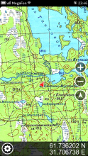
Yozi Explorer
Open source outdoor navigation software for devices running Meego Harmattan. It is compatible with well-known and widely used offline topographic maps in Ozi Explorer formats for PDAs (region.map + region.ozf2 or region.map + region.ozfx3)
Author: dannie
https://code.google.com/p/yozi-meego/
How to use:
Put Ozi Explorer (.map + .ozf2, .map + .ozfx3) maps to /home/user/MyDocs/yozi/maps/. Launch app and start using maps.
Category:
Application versions:
| Attachment | Size | Date |
|---|---|---|
| 353.45 KB | 18/09/2013 - 17:38 |
Changelog:
yozi (0.0.2) unstable; urgency=low
* Fixed issue with positioning methods.
* Added map zoom in/out feature.
* Added more/less detailed map buttons.


Recent comments