
petittrack

PetitTrack is a satellite tracker. PetitTrack is based on the keplerian propagator algorithm used in kd2bd's Predict software. At this stage v1.3.0 the algorithm from 2002.
PetitTrack is a software tool for determining the position of earth satellite orbits in relation to an earth observer.
Before you use the software:
- Download a recent NASA Two Line ELements (TLE) file from CelesTrak or any other source.
- Edit the TLE file and remove any text besides the NASA TLE data (not needed if the file was downloaded from CelesTrak.) The maximum number of satellites that PetitTrack can support is limited to 50. This prevents long startup delays.
- The TLE file should be named nasatle.txt and should reside in /home/nemo/Documents on the Zaurus. Warning: PetitTrack will not start without the TLE file.
- Start PetitTrack by clicking on the PetitTrack Icon.

- Change the default geographical coordinates in the Config tab to your geographical coordinates. The geographic coordinates values are decimal. The Longitude value is positive for locations west of Greenwich and negative for locations east of Greenwich. The Latitude value is positive for locations north of Equator and negative for locations south of Equator. Altitude is in meters. Once you have entered your geographical coordinates, restart PetitTrack so that the changes can take effect.
- The NASA TLE file should be periodically updated to maintain accuracy for the calculations.
PetitTrack has the following tabs:
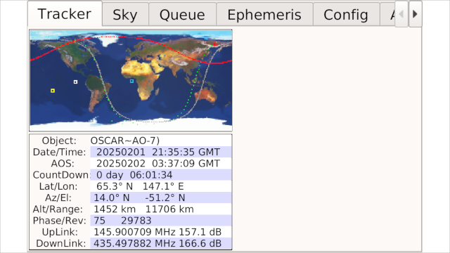
- Tracker - In this tab, the satellite position is displayed in a world map and some pass circustances are shown.
- Sky - The local sky positions for the selected satellite, the sun and the moon are displayed as well as the rise and set times for the sun and moon.
- Queue - The AOS and LOS for the current or next pass for the first 50 satellites present in nasatle.txt will be displayed. A '*' before the AOS cell means that the satellite is currently visible. The selection for the Tracker and Ephemeris tabs is made by clicking on the name of a satellite in the queue.
- Ephemeris - After a satellite is selected in the Queue tab, an Ephemeris table with AOS and LOS times for the next days can be calculated. The number of days can be selected by using the Spin Box at the botton of the tab. To perform the calculations, press the "Calculate" push button. The calculations can be interrupted at any time by pressing the "Stop" push button.
- Config - This is where you enter your geographical coordinates. In this tab you can also select three different types of maps for the Tracker tab and also configure the uplink and downlink frequencies for each satellite.
Screenshots:
Category:
Application versions:
| Attachment | Size | Date |
|---|---|---|
| 194.22 KB | 02/02/2025 - 01:45 | |
| 173.89 KB | 02/02/2025 - 01:45 | |
| 192.86 KB | 02/02/2025 - 01:45 | |
| 172.8 KB | 03/02/2025 - 00:34 | |
| 173.63 KB | 03/02/2025 - 00:34 | |
| 195.27 KB | 03/02/2025 - 00:34 |
Changelog:
* Sun Feb 02 2025 Halftux 1.3.0-2
- fixed settings file
- fixed sailjail permission
* Fri Jan 03 2025 Halftux 1.3.0-1
- ported to qt5/sailfish
Recent comments